Short History and Place Names for Wilkes County, NC
Short History
Created from Surry County and the "district of Washington" in what later became Tennessee
in 1777. Wilkes County was named after John Wilkes who was a member of the English Parliament
that fought for America's Independence. The first
settlers of the area in present-day Wilkes County were primarily German and Scot-Irish immigrants.
The first court of the county was briefly held in the home of John Brown. In 1778, the court moved to the "bent of the Yadkin [River]" and later the same year, it met in the Mulberry Field Meeting House. In June of 1778, commissioners appointed to find a permanent place for the county courthouse, prison, and stocks decided that the location of the Mulberry Field Meeting House was the most central location and thereby the best location for the courthouse. In 1801, Wilkesborough became the first town layed out and in 1825, the courthouse was moved to Wilkesborough.
Boundary and Boundary Changes
Counties surrounding present-day Wilkes County include Alexander (1847), Alleghany (1859), Ashe (1799), Caldwell (1841), Iredell (1788), Surry (1771), Watauga (1849), and Yadkin (1850).
In 1799, Wilkes gave up part of it's northwestern corner and northern borders to create Ashe County. The southwest border of Wilkes Co. was used to create Caldwell County in 1841. In 1847, it's southern border was given up to create Alexander County. Finally, in 1849, part of the western borders were given up to create Watauga County.
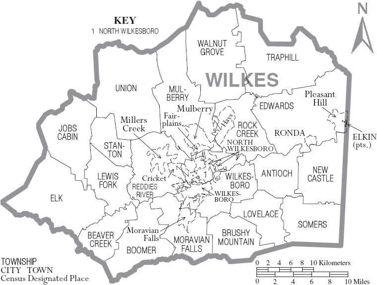
Below are a list of the towns and townships within Wilkes County. Not all those places listed
are on the map above. I've only been able to find more information for a few of places listed below
Antioch
Beaver Creek
Boomer - formerly known as Warrior Creek and renamed for local postmaster who was nicknamed "Boomer"
Brushy Mountains
Cricket - founded 1888
Edwards
Elk
Elkin - partially in Surry County
Fairplains
Hays - post office was established here in the 1890s and named for first postmaster
Jobs Cabin
Lewis Fork - Lewis Fork Baptist Church was organized here 1792
Lovelace - named for Archibald Lovelace, resident in the early 1800s
Millers Creek
Moravian Falls - Established in late 1700s and named for nearby waterfall; formerly knowns as Petersburg and "Forks of the Road"
Mulberry - first settled by Europeans in the 1750s and called the area Mulberry Fields
New Castle - named for plantation of James Clemmons Hunt; known as Hunt's Store in 1840s
North Wilkesboro - founded in 1891; developed around the tracks of Norfolk and Southern Railroad; Daniel Boone (and his family) resided in the present-day area of North Wilkesboro before moving onto to Kentucky; area was described as Mulberry Fields on maps created in 1752 and 1770
Reddies River - community on the shores of Reddies River; settled before the Revolutionary War (exact date unknown)
Rock Creek
Ronda - incorporated 1907; named after the nearby estate of Benjamin Cleaveland's called "Roundabout"
Somers
Stanton
Traphill - settled by 1775; post office established in 1837
Union
Walnut Grove
Wilkesboro - founded in 1800; incorporated 1847; county seat of Wilkes County; interestingly, many Wilkesboro residents remained loyal to the union and not the confederacy during the Civil War;
Above information gleaned from a variety of sources, including the following:
Corbitt, David Leroy. The Formation of the North Carolina Counties: 1663-1943. Raleigh, NC: State Department of Archives and History, 1950